For the last of August and the first few days of September expect temperatures above average through the Great Basin, most of TX, the gulf coast states and Florida, and along the immediate east coast from Georgia north to Maine. Otherwise temperatures at or near normal.
This week features a ridge in the west and a deep trough over the east. Below normal temperatures over much of the NE , the upper Mississippi valley and the Midwest, will gradually moderate through the week as the trough over the east lifts out to the NE, the jet stream mainly moves N into Canada, and the flow across the lower 48 becomes more flat W to E. Over the far-west the immediate coast will cool off but inland areas should remain unseasonably warm.
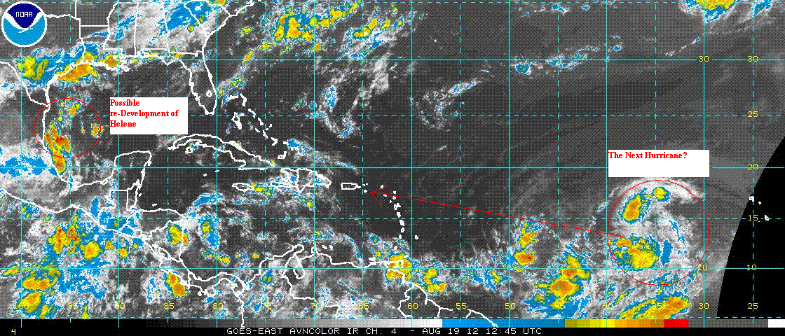
The tropics are busy. This week some models are suggesting the possibility of a re-development this week of tropical storm Helene over the western Gulf of Mexico. Although the overall pattern and conditions over the Gulf are supportive of this scenario, there isn't a model consensus. This area will need to be watched. Over the tropical Atlantic, a large tropical wave is located nearly halfway between the west African coast and the Windward Islands. It is a very large system and has the potential to develop into a very strong hurricane. Ensembles aim this system toward Puerto Rico where it arrives next Thursday. After that the storm tracks separate with some members of the ensemble suggesting a northward re-curvature toward the US East Coast, and the rest continuing this system through the Northern Caribbean and into the Gulf Of Mexico. Climatology suggests a 50/50 chance for either track.
NG price this week may fluctuate significantly as the situation in the tropics develops. Injections to be reported next Thursday should be near the 5 year average.