According to ensembles, for the second week of November it will be warmer than average over the Northeast, Great lakes, upper Midwest and northern Plains, and in the west along the Pacific coast. Near average elsewhere.
This week is a doozy with hybrid tropical cyclone Sandy expected to run onshore the New Jersey coast Monday evening. The most expensive risk is coastal storm surge flooding with tidal levels expected to increase along the Atlantic coast from South Carolina to New England through the next 36-48 hours. Ground zero is NY harbor with sea heights expected to rise up to 3 feet above the seawall protecting Manhattan Monday evening, coincident with high tide, which poses a serious flooding risk for residents in low lying areas of the city and especially for the Subway system. The financial system is likely to face serious effects through the first part of the week, although with their disseminated server farm system I don't expect exchange trading to collapse. Wind damage will be extensive over a large area of the NE as well.
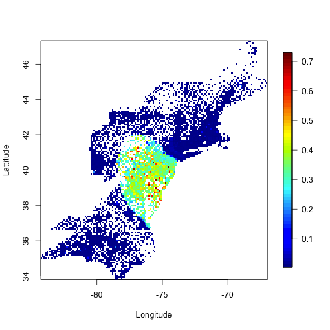
Below is a forecast from Johns Hopkins for power outage potential over the NE from Sandy's winds. The colors correspond to percentages of users without power service due to the storm. You can see outages affecting 50-70% of the population from NYC south to Virginia, and 100's of miles inland through NJ, Pennsylvania, and NY state. A combination of gusts to near hurricane force in the area, wet soils and trees in leaf getting knocked over puts much of the regional grid at risk, and power outages could last for several days and even a week or two in affected areas.
In the wake of this massive storm, cold air will continue to push SE, bringing below normal temperatures to most of the country east of the Rockies through the week. Given the extent of expected power outages, though, NG consumption is likely to drop a bit, with injections at or near the seasonal average overall.
Cool and wet over the Pacific NW this week as a strong jet-stream pushes a series of systems on shore; generally mild and dry over the SW and southern Rockies States.