Happy new year. According to the NAEFS (North American Ensemble) the second full week of January brings above normal temperature along the east coast, NE and Great Lakes, and near normal elsewhere except over the northern Rockies where it will be a little cooler than average. The NAEFS is a blend of the Canadian GEM ensemble and the US GFS ensemble, and I'm not going with the NAEFS this time as the Canadian is an outlier compared to the GFS and the usually reliable European ensemble. Here's why: On day-10, the the CMC has a very amplified pattern with a deep trough running N-S thru the middle of the lower 48. This produces strong SW flow over the East coast and significant warming. On the other hand, both the GFS and the European feature a much less amplified pattern, with the trough axis centered over the Great Lakes and a climatologically favored stationary upper trough centered over Hudson's Bay. Although this pattern will indeed bring some modification of temperatures to the east coast and especially NE during the second week of the year, it won't be nearly as much as the Canadian suggests, and I believe temperatures over the east will remain near normal for the 7-14; i.e. a regular winter pattern. As I suggested last week this is a pretty radical change since the majority of the Nov-December period has been quite warm.
This week features rather quiet conditions with no big storms on the horizon. Cold air is in the headlines as a departing storm over Nova Scotia this morning shunts cold air over the NE and Great Lakes for the next 24 h. Some modification of the cold air takes place in the region later Monday but then an arctic cold front sweeps through Tuesday morning, resulting in the coldest morning of the winter to much of the NE Wednesday. A "clipper" system brings brief near-blizzard conditions to the Great Lakes area next Sunday.
A big upper ridge builds over the west early this week, but deep cold high pressure under the ridge will ensure that conditions there don't warm up much. Another arctic front enters the upper Midwest on Thursday and moves to the to the east coast by Saturday morning providing a re-enforcing shot of cold air to the Lower Midwest, Ohio Valley and the NE. The second arctic front will being snow and localized heavy snow to much of the regions around and to the S and E of the Great Lakes Thurs-Saturday. Seasonally cool conditions will prevail over the SE this week, with cold rain and higher elevation snow on tap for Tuesday-Wednesday. NG demand will run high for the next 2 weeks at least.
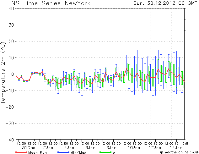
Attached is a European ensemble forecast of NYC surface temps for the next 2 weeks, There is some slight warming 8-12, but not much. Temperatures below normal for the first week of the near and near normal for week 2.