The weather of the third week of January features a progressive cool-off in the east. Generally below to well below normal temperatures are expected over the western half of the lower 48, including Texas; near normal over New England, the Great Lakes states and Ohio Valley, and above normal along the eastern seaboard from south of Maine to the Florida Panhandle. In fact, although the 14th starts off above normal over most of the east, cold air will settle in for a persistent cold period - the coldest of the year, after the 16-17 and well into the last week of the month.
This week features a warm up in the east as a strong west-to-east jet stream sets up over the northern US early in the week, preventing much southward movement of cold air from Canada. By mid week a strong trough moves in from the Pacific and sets up over the west, resulting in southwest flow developing over most of the eastern half of the country and moderating temperatures there to above normal. Temperatures begin to cool off in the eastern half 12-15 as the deep west coast trough shifts very slowly east and a strong low pressure system aloft drops south from the high arctic into Hudson's Bay, bringing increasingly cold air from the NW into the most of the lower 48. Through this time temperatures over most of the inter-mountain west will remain below normal as trapped cold air remains in place. Precipitation-wise, Texas is in for a treat as a deep Pacific trough crosses southern California early in the period (with cold conditions,showers, and significant Sierra snowfalls) and tracks southeastward into extreme western TX by Wednesday evening. The combination of this trough and moisture from the still mild Gulf of Mexico will bring widespread heavy rain and thunderstorms to most of TX Wednesday evening thru Thursday.
NG withdraws to be reported this Thursday should again be greater than the 5 year average.
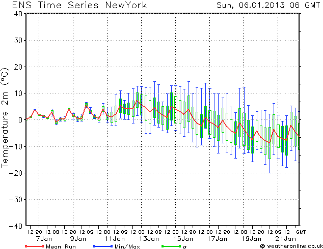
The image is an ensemble model forecast of NYC surface temperatures from the US GFS model through the next few weeks. Early-on near normal, followed by above to well above normal 11-15, followed by significant cooling. Other major models are similar, although there is a lot of uncertainty in the details after the 13th.
The red line is the average of all the ensemble members. For reference, 10C = 50F, 0C = 32F, and -10C = 14F.