A bit of a shift in the temperature pattern is scheduled for after the middle of June with high heat in the west retreating to the deserts around Vegas and inland southern California, and warmth in TX extending N through the southern Plains, the Gulf coast states and the southern Midwest. Elsewhere temperatures should be near normal except a little cooler than normal over the northern Plains and in the immediate vicinity of the upper Great Lakes. This is a slightly bullish pattern as NG consumption for cooling rises.
This week features abnormally high temperatures over most of the west (just not the Pacific NW) that shift gradually east and cool-off. The largest warm anomalies start off in Nevada today (15-20F above normal) and then shift to the southern plains by Tuesday, where it stays warmer than usual through the week, but only by 10F or so after Wednesday. Further N a few slugs of cool air cross the country. The first moves from the upper Midwest today into the NE by Tuesday and the second that moves from the Pac NW tomorrow and over the Northern Plains by the end of the week. Basically what happens this week is that we have a ridge building over the mid-section of the country centered over TX, with weak troughs being established over the NW and the NE.
Thunderstorms should be widespread but scattered over much of the SE this week, and a little more organized and potentially severe over the Northern Plains from Tuesday through the end of the week.
Last year (and the year before) the feature responsible for widespread drought was a ridge that locked into place over TX. As the ridge built it gradually expanded east and north and pushed rainfall further and further out from the centre. It was strong enough to decapitate tropical storm Don in July 2011, and in 2012 the closest any tropical system got was Hurricane Isaac that went ashore over Louisiana in late August. Meteorologists nick-named it the "Texas death ridge" as it killed off any precipitation systems before they got close. This year's building ridge may foreshadow a return of drought to the currently wet areas of the lower Midwest through the summer.
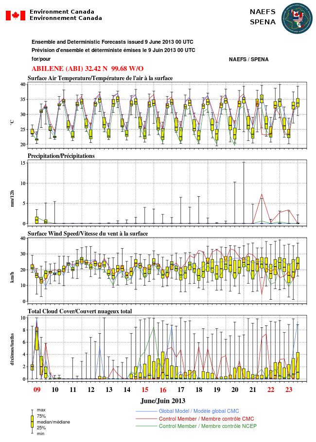
The pic attached is an ensemble forecast of temperature, precipitation, wind and cloud over Abilene TX from now into the forth week of June. Highs near 100 each day, low's in the mid-70's, and precious little rain in sight. Its in English and French since its from the Canadian Weather Service.